




Learn how to measure center pivot irrigation acreage using satellite maps. Explore circular field calculations, pivot radius measurements, partial irrigation coverage, and map-based tools to estimate irrigated farmland in acres.
Large circular fields are easy to recognize in satellite images of farmland. Most of these patterns are created by center pivot irrigation, a method that waters crops using sprinklers rotating around a fixed point. However, the visible circle does not always show the exact amount of land receiving water.
Measuring irrigated acreage helps farmers compare field coverage, plan irrigation operations, and assess equipment performance. Satellite maps make this task easier by allowing users to inspect field boundaries and estimate the size of irrigation circles.
This guide explains how to calculate center pivot acreage using radius measurements, satellite imagery, and map-based tools, including methods for partial pivots and irregular coverage.
What Is Center Pivot Irrigation?
Center pivot irrigation is a sprinkler irrigation method that uses a long pipe structure rotating around a fixed central point. Water travels through the pipeline and reaches crops through sprinklers distributed along its length.
A typical center pivot irrigation system includes a central water supply, connected pipe spans, support towers, wheels, sprinklers, and a drive system.
As the equipment moves, it distributes water across a circular area. This process is commonly called center pivot sprinkler irrigation.
Different center pivot irrigation systems vary in length, sprinkler arrangement, operating speed, and field coverage. Some rotate through complete circles, while others cover only selected portions of a field.
Why Are Center Pivot Irrigation Fields Circular?
Center pivot fields appear circular because the irrigation equipment rotates around a stationary center. Each sprinkler follows a circular path at a different distance from the pivot point.
From above, this movement creates the familiar circular patterns visible across agricultural regions.
These circles may appear green, brown, or differently colored depending on crop growth and field conditions.
However, a visible crop circle does not always match the exact watering boundary. Crop growth, seasonal changes, and equipment settings can influence its appearance.
Satellite imagery provides a useful starting point for measurement, but equipment records may offer additional details about actual coverage.
How to Measure Center Pivot Irrigation Acreage
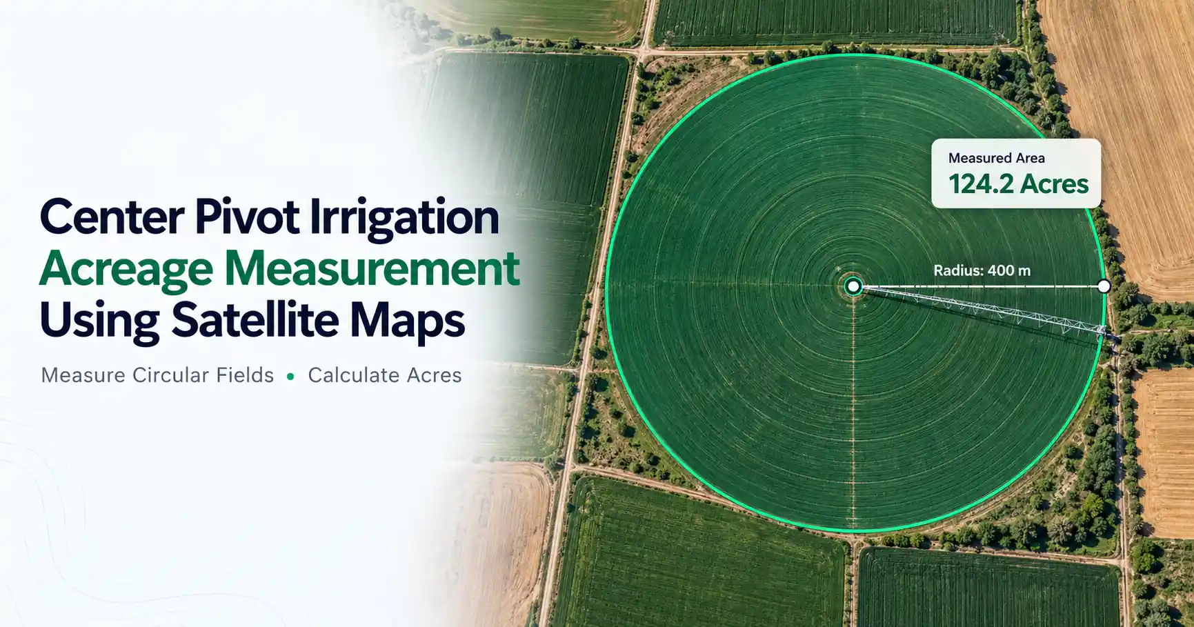
To estimate center pivot irrigation acreage, measure the wetted radius from the pivot center to the outer edge of sprinkler coverage. Calculate the circular area using π multiplied by the radius squared, then convert square feet into acres by dividing by 43,560. Satellite maps can help estimate the radius or trace the irrigated boundary.
For a complete circle, use:
Irrigated Acres = (π × Radius²) ÷ 43,560
This formula assumes the radius is measured in feet.
The wetted radius should represent the distance reached by irrigation water, which may extend beyond the last support tower.
Partial-circle operation and equipment that extends coverage require adjustments.
How to Find Pivot Radius and Diameter on a Satellite Map
The radius is the distance from the center pivot to the outer edge of irrigation coverage. The diameter measures the full distance across the circle through its center.
To estimate these dimensions, locate the pivot center on satellite imagery. Then measure outward toward the visible irrigation boundary.
If the field forms a clear circle, measuring the diameter and dividing it by two provides another way to estimate the radius.
Check several directions when the field appears uneven. End guns, obstacles, and changes in crop growth can affect the visible outline.
Remember that the equipment's physical length may not equal the wetted radius.
How Many Acres Does a Center Pivot Cover?
The acreage depends mainly on the system's wetted radius and how much of the circle it irrigates.
For example, a pivot with a 1,000-foot wetted radius covers approximately 72.13 acres when it waters a complete circle.
A system with a quarter-mile wetted radius, equal to 1,320 feet, would cover approximately 125.66 acres under the same conditions.
Neither figure represents every irrigation center pivot installation. Systems have different lengths, sprinkler arrangements, and operating limits.
A longer radius increases coverage substantially because circular area grows with the square of the radius.
Center Pivot Irrigation Acreage Examples
The following table shows theoretical full-circle coverage for different wetted radii.
Wetted Radius | Approximate Irrigated Acres |
| 500 ft | 18.03 |
| 750 ft | 40.57 |
| 1,000 ft | 72.13 |
| 1,250 ft | 112.70 |
| 1,300 ft | 121.88 |
These calculations assume complete circular coverage with a constant wetted radius.
Doubling the radius increases the irrigated area fourfold. Actual coverage may differ because of equipment settings, operating angles, and field boundaries.
How to Measure Center Pivot Acreage Using Satellite Maps
Satellite maps help estimate acreage without requiring every field boundary to be measured on the ground.
Follow these steps:
Open a satellite map or GIS-based area measurement tool.
Search for the farm or agricultural field.
Switch to satellite imagery if necessary.
Identify the irrigation circle and central pivot point.
Zoom in to inspect the visible outer boundary.
Select an area measurement tool.
Place connected points around the irrigation circle.
Close the boundary and review the calculated acreage.
Compare the estimate with available equipment records or field measurements.
For a regular circular field, measuring the radius may be sufficient. For uneven coverage, tracing the visible boundary can provide a more useful estimate.
Satellite imagery represents conditions from a particular date. A field's appearance may change with the growing season or irrigation activity.
Measuring Center Pivot Acreage With Google Earth
Google Earth can help users examine agricultural fields and measure geographic areas in supported versions.
After locating the irrigation circle, users can measure a radius or outline the field using an area measurement feature.
A polygon drawn around the visible irrigated region can estimate acreage, including areas that are not perfectly circular.
The method is especially useful when field boundaries interrupt the irrigation pattern.
However, satellite imagery cannot always reveal the exact reach of every sprinkler. Use the result as an estimate unless better field measurements are available.
Using a Map Area Calculator for Irrigation Fields
A map area calculator can simplify acreage measurement by calculating the space inside a selected boundary.
Users can place points around the visible irrigation boundary and review the result in available measurement units.
This approach is helpful when a pivot does not form a complete circle.
However, a map calculator measures the shape you select. It cannot automatically confirm that every part of that shape receives irrigation water.
How to Calculate Partial-Circle Center Pivot Acreage
Some center pivots operate through only part of a circle because of field boundaries, roads, obstacles, or operating restrictions.
Partial-circle acreage depends on the angle covered.
A half-circle pivot covers 180 degrees, representing half the full-circle area. A quarter-circle covers 90 degrees, while a three-quarter circle covers 270 degrees.
For example, a 1,000-foot-radius system that waters only half a circle covers approximately 36.06 acres.
The calculation assumes the wetted radius remains constant throughout the irrigated portion.
When coverage changes with direction, measuring the actual outline may produce a better estimate.
Why Doesn't a Center Pivot Irrigate Every Acre of a Square Field?
A standard quarter-section field contains approximately 160 acres, but a circular irrigation system cannot cover every corner of a square field using only its regular circular pattern.
Even when the pivot operates through a complete rotation, areas outside the circle remain uncovered.
Some quarter-section systems irrigate around 130 acres, although actual coverage depends on equipment design and field layout.
The total field acreage should therefore be distinguished from the irrigated acreage.
This difference matters when comparing land available for farming with land actually reached by irrigation water.
How Do End Guns and Corner Systems Affect Acreage?
An end gun is a sprinkler installed near the outer end of a pivot. It can extend watering beyond the regular sprinkler spans.
Some systems activate end guns only during selected portions of the rotation to avoid roads, neighboring properties, or other restricted areas.
Corner systems use additional equipment to reach parts of square fields that conventional circular coverage misses.
These features can increase irrigated acreage, but they also make the coverage pattern more complex.
When the effective radius changes, one circle formula may not describe the entire area accurately. An equipment coverage plan or carefully traced map boundary may be more useful.
How Accurate Is Satellite-Based Irrigation Acreage Measurement?
Satellite-based acreage estimates depend on image quality, boundary visibility, and correct measurement-point placement.
High-resolution imagery may make irrigation circles easier to identify, while older or unclear images can create uncertainty.
Crop appearance is another limitation. A green circular field may indicate an irrigation pattern, but it does not prove how far water currently reaches.
End guns, partial rotations, and changing crop conditions can also complicate measurements.
For general planning, satellite maps offer a practical estimate. For precise equipment assessments, compare the mapped area with irrigation plans and suitable field measurements.
Common Mistakes When Measuring Center Pivot Acreage
A common mistake is confusing the diameter with the radius. Using the full diameter as the radius greatly overstates the calculated area.
Another problem is measuring the distance to the final support tower instead of the actual wetted edge.
Farmers may also calculate the full-circle area even when a system irrigates only part of its rotation.
Ignoring end guns, corner attachments, or field boundaries can produce misleading results.
Finally, avoid assuming that the entire agricultural property is irrigated simply because a center pivot operates within it.
Why Is Measuring Irrigated Acreage Useful?
Knowing irrigated acreage helps farmers compare fields, review equipment coverage, and maintain agricultural land records.
It can also support early irrigation planning by showing how much land a system is intended to water.
However, acreage alone cannot determine total water use, pumping requirements, or irrigation efficiency.
Those calculations require additional information, including water application depth, crop needs, system capacity, and operating conditions.
Final Thoughts
Center pivot irrigation commonly creates circular patterns that can be measured using satellite maps. The wetted radius is the main dimension needed to calculate theoretical full-circle acreage.
For partial pivots or systems with end guns and corner attachments, tracing the coverage boundary may provide a more useful estimate.
Remember that total field acreage and irrigated acreage are not always equal. Combining satellite measurements with equipment information and field records can help produce more dependable results.
Frequently Asked Questions
Center pivot irrigation is a sprinkler system that rotates around a fixed central point to water crops. It commonly creates circular irrigation patterns across agricultural fields.
Coverage depends on the wetted radius and operating angle. A system with a 1,000-foot radius covers approximately 72.13 acres when irrigating a complete circle.
For a full circle, multiply π by the radius squared and divide by 43,560 when the radius is in feet. Partial-circle systems require an adjustment for the coverage angle.
Yes. Satellite maps and suitable area measurement tools can estimate acreage by tracing the irrigation boundary. Results depend on image quality and accurate point placement.
Usually not with conventional circular coverage alone. A center pivot inside a square field generally leaves corner areas outside the circle. End guns and corner systems can extend coverage.
Calculate the theoretical full-circle acreage, then multiply it by the fraction of 360 degrees irrigated. For example, a half-circle pivot covers approximately half the full-circle area when its wetted radius remains constant.