




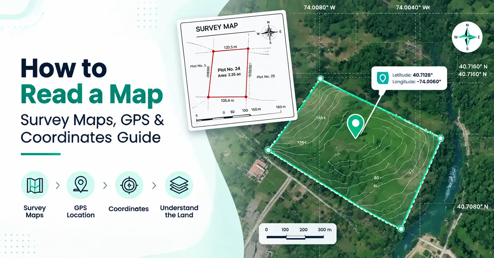
How to read a map with survey maps, GPS coordinates, topographic maps, latitude, longitude, and contour lines for construction, surveying, and land planning.
Maps are essential tools for understanding locations, measuring distances, and planning projects. Learning how to read a map helps construction professionals, surveyors, engineers, property planners, and students understand real-world locations accurately. Maps provide important information about land features, boundaries, directions, distances, and coordinates that help people make better decisions.
Whether you are working with a survey map, topographic map, or GPS-based digital map, reading the information correctly is important. By understanding map scales, symbols, compass directions, latitude and longitude, and elevation details, you can interpret maps for construction planning, land measurement, navigation, and property development.
What Is Map Reading?
Map reading is the process of understanding and interpreting information shown on a map. A map is a visual representation of a real-world area that uses symbols, measurements, and coordinates to display locations and features.
For professionals involved in construction and land measurement, map reading is an important skill. It helps identify property boundaries, measure distances, understand terrain conditions, and plan development projects.
A map contains several important elements, including:
Location information
Distance measurements
Direction indicators
Land features
Property details
Geographic coordinates
Understanding these elements allows users to convert map information into practical decisions. For example, engineers can analyze land conditions before construction, while surveyors can verify property boundaries using accurate map data.
Basic Elements of a Map
Before learning how to read a map, it is important to understand the basic components that appear on most maps.
Map Title
The map title explains the purpose and area covered by the map. It helps users understand whether they are viewing a road map, survey map, topographic map, or another type of map.
For example, a land survey map may show property boundaries, while a topographic map focuses on elevation and terrain information.
Map Scale
Map scale shows the relationship between distance on the map and the actual distance on the ground.
For example:
1 inch = 100 feet
means one inch measured on the map represents 100 feet in real life.
Understanding scale is important for:
Measuring land distances
Planning construction layouts
Estimating property sizes
Calculating travel distances
A wrong understanding of scale can lead to inaccurate measurements.
Map Legend and Symbols
The legend explains the symbols used on the map. Different maps use different symbols to represent real-world features.
Common symbols may show:
Roads
Buildings
Rivers
Property boundaries
Survey markers
Elevation points
Learning these symbols makes it easier to understand map information quickly.
Compass Direction
Maps usually include a north direction indicator. A compass helps users understand the orientation of the map.
The four main directions are:
North
South
East
West
Knowing directions helps users identify locations and plan routes accurately.
How to Read a Map Step by Step
Understanding how to read a map becomes easier when you follow a structured approach.
Step 1: Identify the Map Type
First, determine what type of map you are using. Different maps provide different information.
A road map focuses on transportation routes, while a survey map provides property details. A topographic map shows terrain and elevation.
Step 2: Check the Map Scale
Before measuring anything, understand the scale. This helps convert map measurements into actual ground distances.
For example, construction professionals use map scale information to estimate site dimensions before beginning detailed surveys.
Step 3: Understand Symbols and Labels
Review the map legend to identify important features. Symbols can show boundaries, structures, roads, water bodies, and other geographic information.
Step 4: Find Your Location
Identify your current position or the area you want to study. On digital maps, GPS coordinates can help locate exact positions.
Step 5: Use Directions and Coordinates
Use compass directions, latitude, longitude, or GPS coordinates to identify exact locations.
Step 6: Measure Distance or Area
Maps can help estimate distances and areas. Professionals often combine map data with GPS tools and measurement software for more accurate results.
How to Read a Survey Map?
A survey map is a detailed map used by surveyors, engineers, and construction professionals to understand land information. Learning how to read a survey map helps users identify exact property details before development.
A survey map usually includes:
Property boundaries
Plot dimensions
Survey points
Reference markers
Roads and access areas
North direction
Survey maps are created using accurate measurements collected from the land. They help verify property ownership details, prepare construction plans, and prevent boundary-related issues.
For example, before constructing a building, engineers use survey maps to understand the exact plot size and available construction area.
How to Read a Property Survey Map?
A property survey map provides detailed information about a specific piece of land. Understanding how to read a property survey map helps homeowners and builders understand their property limits.
Important details include:
Property Lines
Property lines show the legal boundaries of the land. They help identify where one property ends and another begins.
Lot Numbers
Many survey maps include lot numbers that identify specific properties within a development.
Easements
Easements indicate areas where others may have certain usage rights, such as access roads or utility lines.
Setbacks
Setbacks show required distances between buildings and property boundaries.
These details are important for construction planning because they determine where structures can be built.
How to Read a Land Survey Map?
A land survey map provides accurate information about land measurements and boundaries. Unlike regular maps, land survey maps focus on exact property details.
To understand how to read a land survey map, look for:
Boundary points
Coordinates
Bearings
Distances
Legal descriptions
Surveyors use these details to define exact property locations.
For example, coordinates help identify specific points on the land, while bearings describe the direction between boundary points.
Land survey maps are especially useful for property development, construction planning, and resolving boundary questions.
How to Read a Topographic Map?
A topographic map shows the physical features and elevation changes of an area. Learning how to read a topographic map helps users understand terrain before planning construction or land development.
Unlike regular maps, topographic maps include elevation information through contour lines.
They show:
Hills
Valleys
Slopes
Elevation points
Natural features
Engineers and planners use topographic maps to evaluate land conditions before designing roads, buildings, drainage systems, and other structures.
How to Read a Contour Map?
A contour map uses lines to represent changes in elevation. Understanding how to read a contour map helps determine whether land is flat, steep, or uneven.
Contour lines show areas with the same elevation.
The spacing between lines indicates slope:
Close contour lines indicate steep slopes.
Wide contour lines indicate gentle slopes.
Contour information is useful for:
Construction planning
Road development
Drainage design
Land analysis
For example, engineers can identify whether a construction site requires additional preparation because of uneven terrain.
How to Read a Map Using a Compass?
Many people ask how to map read using a compass because a compass helps determine direction and orientation.
The basic steps are:
Place the compass on the map.
Align the map with north.
Identify the required direction.
Follow the calculated route.
Compass navigation is useful for outdoor activities, surveying, and situations where GPS signals may not be available.
How to Read Latitude and Longitude on a Map?
Latitude and longitude create a coordinate system used to identify exact locations anywhere on Earth.
Latitude lines show north and south positions. They run horizontally around the Earth.
Longitude lines show east and west positions. They run vertically from the North Pole to the South Pole.
For example:
40.7128° N, 74.0060° W
represents a specific location using latitude and longitude coordinates.
Understanding how to read a map latitude and longitude is important for GPS navigation, surveying, and geographic information systems.
How to Read a Map With Longitude and Latitude?
Learning how to read a map with longitude and latitude allows users to locate exact points instead of relying only on visual landmarks.
GPS devices use these coordinates to provide accurate location information. Surveyors and engineers use coordinates for:
Land measurement
Mapping
Construction projects
Property planning
Digital mapping tools combine GPS coordinates with satellite data to improve location accuracy.
GPS Maps and Modern Digital Mapping
Modern GPS maps have changed how people understand and use maps. Unlike traditional paper maps, digital maps provide real-time location information and interactive features.
GPS-based mapping tools can help with:
Real-time location tracking
Distance measurement
Area calculation
Coordinate identification
For construction and surveying professionals, GPS technology improves efficiency by providing accurate location data during fieldwork.
Common Mistakes While Reading Maps
Some common map-reading mistakes include:
Ignoring map scale
Misunderstanding symbols
Confusing latitude and longitude
Not checking map direction
Ignoring contour intervals
Understanding these details improves accuracy and prevents incorrect measurements.
Conclusion
Learning how to read a map is an essential skill for construction professionals, surveyors, engineers, and property planners. Survey maps, GPS coordinates, and topographic maps provide valuable information about land, locations, boundaries, and terrain.
By understanding map scale, symbols, coordinates, and elevation data, professionals can make better decisions during construction planning, land surveying, and property development. Using accurate mapping tools and GPS technology makes measurement and analysis faster, easier, and more reliable.
Frequently Asked Questions (FAQs)
To read a map, understand its scale, symbols, directions, coordinates, and important features. These elements help identify locations and measure distances.
A topographic map is read by understanding contour lines, elevation points, and terrain features such as hills and slopes.
A survey map is read by examining boundaries, dimensions, coordinates, reference points, and property information.
A property survey map shows property lines, lot numbers, easements, setbacks, and building locations.
A land survey map is interpreted using coordinates, bearings, distances, and boundary information.
Use a compass to identify north, align the map direction, and follow the required bearing.
Latitude shows north and south position, while longitude shows east and west position.
A topographic map shows elevation and terrain details, while a regular map mainly shows locations and routes.
GPS uses latitude and longitude coordinates to identify exact locations on Earth.
Contour lines show elevation changes and help users understand terrain and slopes.