




How close are two places if roads and turns are ignored? Discover what as the crow flies distance means and how to measure the direct distance between any two locations.
Two places can look close on a map but take much longer to reach by road. That happens because roads turn, cross bridges, avoid obstacles, and rarely follow a perfect straight line. As the crow flies distance measures the direct separation between two locations instead.
This type of distance is useful when you want to compare how close places really are without considering a travel route. You can measure it with map tools, a distance calculator, or geographic coordinates. Knowing the difference between direct and route distance can help with map reading, location comparisons, basic planning, and geographic analysis.
What Does As the Crow Flies Distance Mean?
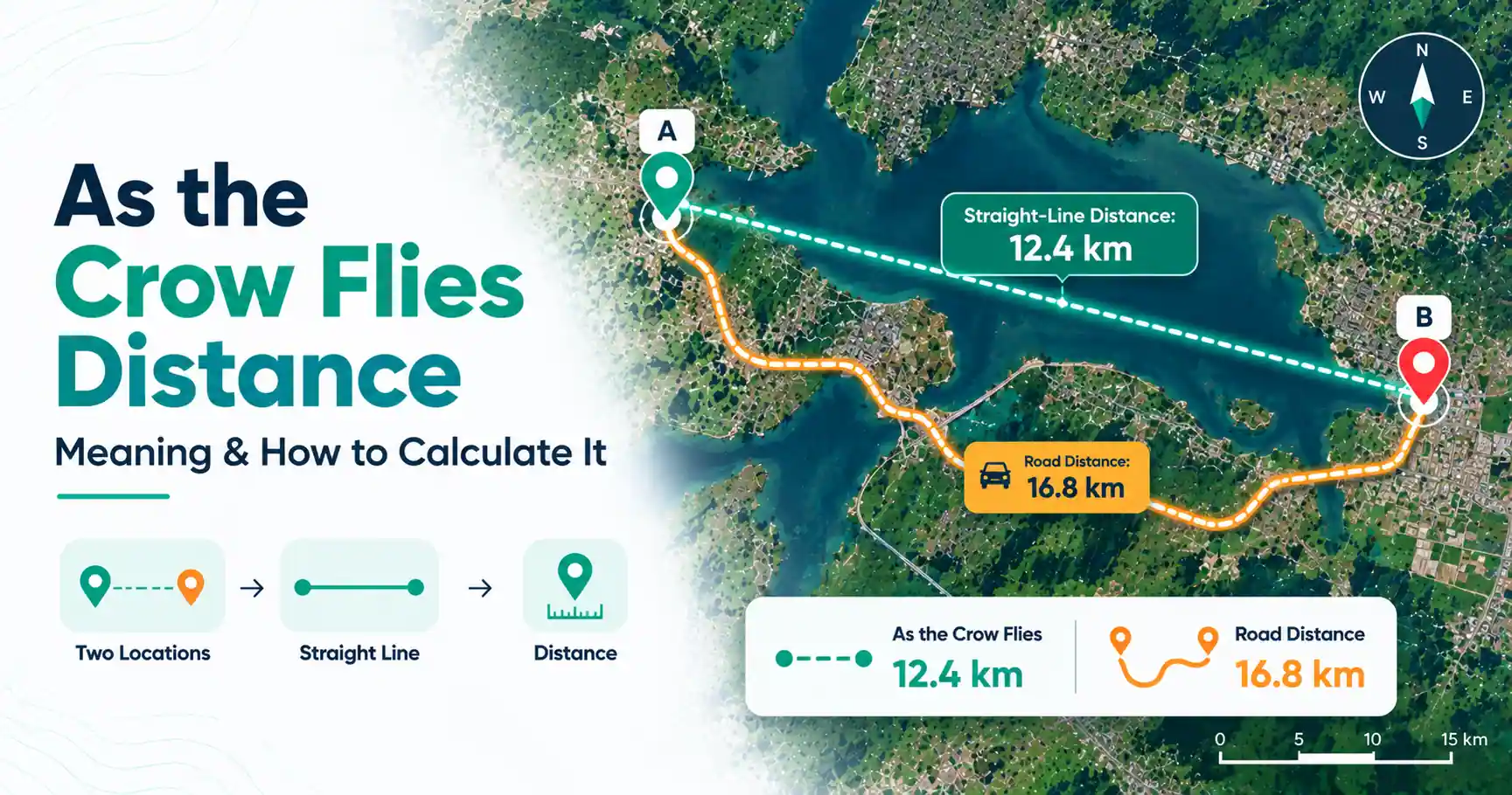
As the crow flies distance is the direct distance between two locations without following roads, paths, or other travel routes. It represents the shortest geographic separation between two points, although calculations over the Earth's curved surface may follow a great-circle path rather than a straight line on a flat map.
For a simple example, imagine two locations that are 5 miles apart in direct distance. The road connecting them might cover 7 miles because it bends around buildings, rivers, hills, or other features.
In that case, the distance as the crow flies is about 5 miles, while the driving distance is 7 miles.
Why Is It Called "As the Crow Flies"?
The phrase creates a simple picture: a bird can fly toward a destination without having to follow roads on the ground.
A person driving between the same locations may need to take turns or follow a longer route. "As the crow flies" therefore became a useful expression for describing direct distance rather than route distance.
It does not mean that an actual crow must fly between the two places. The phrase is simply a way to describe direct geographic separation.
As the Crow Flies Distance vs Driving Distance
The main difference is what each measurement follows.
As the crow flies distance measures direct separation between two points. It does not follow the road network, turns, intersections, or a suggested navigation route.
Driving distance follows roads that a vehicle can use. This route may curve or move away from the destination before approaching it again.
Suppose your home and a park are 3 miles apart in direct distance. A river lies between them, and the nearest bridge is farther north. Your driving route might therefore be 5 miles.
Neither measurement is wrong. They answer different questions. Direct distance tells you how far apart the locations are geographically. Driving distance tells you how far you may need to travel by road.
How to Calculate As the Crow Flies Distance
You can calculate direct distance with a map measurement tool, an as the crow flies distance calculator, or the latitude and longitude of the two locations. The best method depends on whether you want a quick result or need to work with geographic data.
Method 1: Measure Two Points on a Map
A map measurement tool is one of the easiest options.
First, select your starting point, or Point A. Next, select the destination, or Point B. The measurement tool can then show the direct distance between those two points.
This differs from requesting directions. A directions feature normally finds a usable road, walking, or cycling route. A straight-line measurement ignores that route and measures the separation between the selected points.
For basic comparisons between locations, this method is often enough.
Method 2: Use an As the Crow Flies Distance Calculator
An as the crow flies distance finder or calculator can automate the process. Depending on the tool, you may enter place names, addresses, coordinates, or select locations directly on a map.
The basic process is:
- Enter or select your starting location.
- Enter or select your destination.
- Calculate the direct distance.
- View the result in miles, kilometers, or another available unit.
A distance calculator as the crow flies tool is especially useful when you need the geographic separation rather than a road route.
Check the locations before accepting the result. Selecting the wrong town, address, or map point can change the measurement.
Method 3: Calculate Distance Using Latitude and Longitude
If you know the latitude and longitude of both locations, you can calculate their geographic distance mathematically.
For nearby points on a suitable projected map, simple planar methods may sometimes be used. Over larger parts of the Earth, however, its curved shape matters.
This is where great-circle distance becomes useful. A great-circle calculation estimates the shortest path between two points along a spherical model of the Earth's surface.
The Haversine formula is one common method for calculating this type of distance from latitude and longitude. Most people do not need to perform the calculation manually because mapping and distance tools can handle the mathematics.
How to Find the Distance Between Two Places As the Crow Flies
To find the distance between two places as the crow flies, identify the exact starting and ending locations and measure the direct geographic separation between them.
Think of it as three parts:
Point A → Direct measurement → Point B
Suppose a school and a library are on opposite sides of a river. The direct line between them might measure 1.5 miles. A road route could be longer because it must reach a bridge before crossing the river.
The river changes how you travel, but it does not change the direct separation between the two selected points.
Can Google Maps Calculate As the Crow Flies Distance?
Yes. Google Maps includes a Measure distance feature that can measure straight-line distance between selected points. This is different from using Directions, which calculates a route based on a chosen mode of travel.
For an as the crow flies distance Google Maps measurement, the important idea is to use straight-line measurement rather than a driving, walking, or cycling route.
You can also add multiple measurement points, but doing so creates a series of line segments. If you want the direct distance between two locations, measure only the intended start and end points.
How Far Away Am I As the Crow Flies?
To find how far another location is from you in direct distance, first identify your current position and the destination.
Then:
- Set your location as the starting point.
- Select the destination.
- Use a straight-line measurement or distance finder.
- Read the result in miles or kilometers.
If a website or app detects your current position automatically, it may ask for location permission. You can also enter a starting location manually when supported.
This gives geographic separation, not necessarily the distance you would drive or walk.
When Is As the Crow Flies Distance Useful?
Direct distance can be useful whenever you care about proximity rather than a specific travel route.
Common uses include:
- Comparing how close two towns or landmarks are
- Checking the direct separation between properties
- Studying geographic patterns on maps
- Comparing locations before planning a route
- Supporting basic GIS and spatial analysis
- Estimating proximity during outdoor planning
- Comparing possible sites or service areas
It can also provide useful context when two places seem nearby but have a surprisingly long road connection.
However, direct distance should not replace route planning when you need actual travel distance or time.
What Does "2 Miles As the Crow Flies" Mean?
If somewhere is 2 miles as the crow flies, the two locations are separated by about 2 miles when measured directly rather than along a road or path.
You might still need to drive or walk more than 2 miles to reach it. Roads, buildings, rivers, restricted areas, and other obstacles can make the usable route longer.
As the Crow Flies Distance on a Map
An as-the-crow-flies map lets you visualize the direct separation between two locations.
You select two map points, and a line connects them. The measured line represents direct geographic distance rather than a suggested travel route.
An as the crow flies distance finder may combine this visual line with a result in miles or kilometers. This makes it easier to compare straight-line distance with a route shown by a navigation tool.
Common Mistakes When Measuring Straight-Line Distance
Direct distance is simple in concept, but a few mistakes can produce misleading results.
One common error is using a directions feature instead of a straight-line measurement tool. Another is adding intermediate points, which measures several connected segments rather than the direct separation between the original locations.
Also avoid treating direct distance as travel time. A place 3 miles away geographically may require a much longer journey.
For longer distances, the Earth's curvature also matters. Geographic calculations should account for the Earth's surface rather than assuming every map is perfectly flat.
Finally, check your units. Three kilometers and three miles represent different distances.
Final Thoughts
As the crow flies distance tells you how far apart two locations are without following roads or other travel routes. You can find it with map measurement features, online calculators, or geographic coordinates.
The key is knowing what the result represents. Straight-line distance is useful for comparing geographic proximity, while route distance is more useful for planning an actual journey. When working across larger areas, calculations based on latitude, longitude, and the Earth's curved surface provide a more suitable geographic measurement.
Frequently Asked Questions
Yes. Google Maps has a Measure distance feature for measuring straight-line distance between selected map points. This is different from Directions, which calculates driving, walking, cycling, or other supported routes. For direct distance, use the measurement feature rather than a route result.
To get distance as the crow flies, choose your starting and ending locations in a straight-line map tool or distance calculator. You can also calculate the distance from their geographic coordinates. The result represents direct geographic separation instead of the length of a road or walking route.
For a quick result, select both points with a straight-line map measurement tool. If you have latitude and longitude, geographic distance can also be calculated mathematically. For points across the Earth's surface, methods such as a great-circle calculation or the Haversine formula are commonly used.
Common alternatives include straight-line distance, direct distance, and sometimes aerial distance. The best term depends on context. Straight-line or direct distance is usually clear when comparing two map locations without referring to roads or travel routes.
Yes. Mapping and distance-measurement tools can let you select two locations and display a direct line between them. The length of that line represents their direct geographic separation. This differs from a navigation map that follows roads or paths between the same locations.
For the same two endpoints, direct geographic separation is generally no greater than a road route connecting them. Roads usually include curves and turns instead of following the direct path. The comparison can vary, however, if different endpoints or measurement methods are used.