




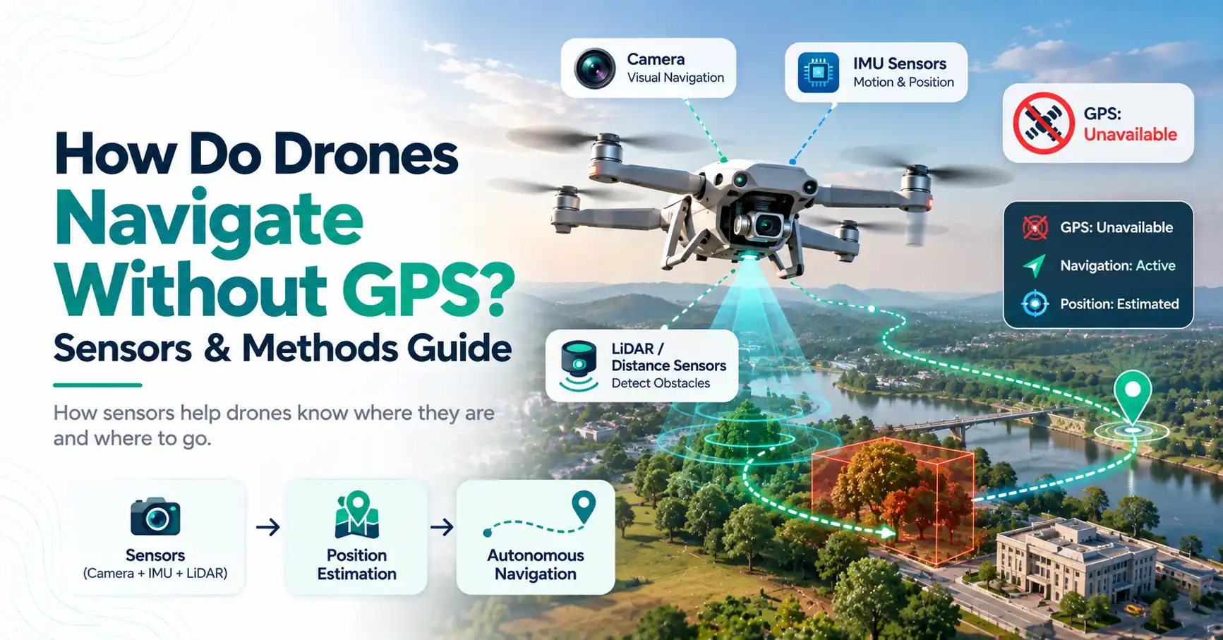
What happens when a drone loses its GPS signal? Discover how drones use cameras, IMUs, LiDAR, SLAM, and other sensors to navigate, stay stable, and avoid obstacles without GPS.
GPS helps many drones know where they are, but satellite positioning is not available everywhere. A drone may fly indoors, between tall buildings, or in another place where GPS reception is weak. So, how do drones navigate without GPS in these conditions?
Some drones use cameras, motion sensors, altitude sensors, LiDAR, and onboard software to estimate where they are and how they are moving. More advanced systems can also build maps and detect obstacles as they fly. These technologies do not make every drone independent of GPS, but they can provide other ways to maintain stability, estimate position, and navigate when satellite signals are unavailable. Pasted text
Can Drones Navigate Without GPS?
Yes, some drones can navigate without GPS by combining onboard sensors such as inertial measurement units (IMUs), cameras, optical-flow sensors, LiDAR, and barometers. The exact ability depends on the drone and its environment. GPS-free flight may also have more limits than normal GPS-assisted navigation.
A drone does not always need a geographic position to stay level. Basic onboard sensors can help stabilize it even when GPS is unavailable.
However, stable flight and autonomous navigation are different. Staying level does not mean the drone knows its exact location or can independently reach a destination.
How Does a Drone GPS System Work?
A drone GPS system receives signals from navigation satellites and uses them to estimate geographic position. Many drones actually support GNSS, or Global Navigation Satellite Systems. GPS is one system within the broader GNSS category.
When discussing drones and GPS, satellite positioning can support features such as position hold, waypoint navigation, route planning, and return-to-home on compatible models.
GPS is not usually the only system keeping a drone in the air. The flight controller also receives information from motion, altitude, and other sensors. This allows it to manage orientation and stability even when satellite positioning changes.
How Do Drones Navigate Without GPS?
When GPS is unavailable, capable drones estimate their movement and surroundings using several onboard sensors. These may provide information about orientation, acceleration, altitude, nearby objects, and relative position.
A key idea is sensor fusion. Instead of trusting one sensor for everything, the flight system combines information from several sources.
For example, an IMU may detect movement while a camera estimates how the drone has moved relative to the ground. A barometer can provide altitude information. Combining these inputs can produce a more useful position and motion estimate.
1. Inertial Measurement Unit (IMU)
An inertial measurement unit is one of the basic sensing systems found in many drones. It commonly includes an accelerometer and gyroscope.
An accelerometer senses acceleration. A gyroscope measures rotational movement. Together, they help the flight controller understand how the drone is moving and oriented.
This information is valuable even without GPS. It can help the drone react when it tilts, turns, speeds up, or slows down.
However, an IMU has limitations for long-term position estimation. Small measurement errors can build up over time. This effect is often called drift, which is one reason other sensors may be combined with the IMU.
2. Compass and Barometer
A magnetometer, often used as an electronic compass, can provide information about heading. It helps the system understand which direction the drone is facing.
A barometer measures air pressure and can help estimate changes in altitude. This can support height control alongside other sensors.
Neither sensor replaces GPS on its own. Instead, each supplies another piece of information that the flight controller can use.
3. Optical Flow
Optical flow uses visual changes to estimate relative movement. A camera or optical-flow sensor observes patterns in the scene and tracks how those patterns shift as the drone moves.
For example, a downward-facing sensor may watch the ground. If ground features move across its view, the system can use that change to estimate the drone's motion relative to the surface.
Optical flow can be useful where GPS reception is weak or unavailable. Its performance, however, can depend on lighting, visible surface detail, camera quality, and height above the surface.
A dark room or a plain surface with few visible features may make visual tracking harder.
4. Visual Odometry
Visual odometry also uses cameras, but it does more than simply record video. It tracks recognizable features across successive images and uses their changing positions to estimate movement.
Imagine a camera seeing the corner of a window. As the drone moves, that corner appears at different places in each frame. Software can analyze these changes as part of estimating how the drone itself moved.
Visual odometry can support navigation where satellite positioning is unavailable. Low light, motion blur, blocked cameras, or environments with few distinct visual features can reduce its effectiveness.
5. SLAM: Mapping While Locating the Drone
SLAM stands for Simultaneous Localization and Mapping. It describes a process in which a system builds or updates a map of its surroundings while also estimating its position within that map.
This can be valuable in an unfamiliar indoor environment. Instead of depending on global coordinates, an advanced drone can observe nearby features and use them as references for local navigation.
SLAM may use cameras, LiDAR, or other sensor data, depending on the system. It is especially useful in some autonomous and GPS-denied applications.
Not every consumer drone supports SLAM, and its performance depends heavily on the sensors, software, and environment.
6. LiDAR and Depth Sensors
LiDAR measures distances to surrounding surfaces using laser light. It can provide information about the shape and distance of objects around a drone.
Depth cameras and other ranging sensors can serve related purposes. Their measurements may support mapping, localization, obstacle detection, and controlled movement through an environment.
For example, distance data can help a capable system recognize that a wall or other object is nearby.
Sensor packages differ greatly between drone models. LiDAR should not be treated as a standard feature on every drone.
How Do Drones Navigate and Avoid Obstacles?
Drones with obstacle-avoidance systems may use cameras, LiDAR, depth sensors, ultrasonic sensors, or other proximity sensors to detect objects around them.
The flight controller can use that information to warn the pilot or, on supported systems, slow down, stop, or adjust a planned path. The exact response depends on the drone.
This helps answer how do drones navigate and avoid obstacles, but navigation and obstacle avoidance are not the same thing.
Navigation is about estimating where the drone is and how it should move toward a goal. Obstacle avoidance focuses on detecting and responding to objects that may block its path.
A drone may have strong navigation features but limited obstacle sensing in certain directions.
How Do Drones Navigate Autonomously?
To understand how do drones navigate autonomously, think of autonomous flight as several systems working together rather than one sensor controlling everything.
A capable autonomous system may combine:
- Position estimation
- A route or destination
- Data from onboard sensors
- Obstacle detection
- Flight-control decisions
Sensor fusion connects many of these functions. When GPS is available, GPS, an IMU, cameras, and a barometer may all contribute information. When GPS is unavailable, visual and inertial sensors may take a larger role in localization.
Autonomy also varies by drone. Following a preset waypoint route is different from independently mapping an unknown environment and responding to obstacles.
What Is GPS-Denied Navigation?
A GPS-denied environment is a place where reliable satellite positioning is unavailable or unusable. This may happen in some indoor or underground spaces, locations with major signal obstruction, or areas affected by interference.
GPS denied navigation refers to using other sensing and localization methods instead of relying only on satellite positioning.
A capable system might combine inertial sensing, cameras, visual odometry, SLAM, altitude sensors, or ranging sensors. The exact approach depends on the aircraft and its intended use.
GPS-denied navigation is therefore not one single technology. It is a broader problem solved through different combinations of sensors and software.
Limitations of Drone Navigation Without GPS
GPS-free navigation has trade-offs. No single onboard sensor performs perfectly in every environment.
IMU errors can build over time. Cameras may struggle in darkness, bright glare, or places with few visible features. Weather and poor visibility can affect some sensing systems, while LiDAR and depth sensors have their own range and environmental limits.
Advanced navigation also requires processing power to analyze sensor data and make decisions quickly.
This is why sensor fusion is valuable. One sensor can provide information that another sensor cannot, helping the flight system create a more complete estimate of its movement and surroundings.
What Happens If a Drone Loses GPS?
What happens after GPS is lost depends on the drone, its sensors, software, and current flight mode.
A capable drone may continue using other positioning sensors. Another may switch flight modes or lose some position-hold ability, meaning the pilot needs to provide more control.
The response is model-specific. Losing GPS does not always cause a crash, but it also does not mean every drone can continue autonomous navigation normally.
Return-to-home should not be assumed either. That feature can depend on reliable positioning and the manufacturer's design.
Final Thoughts
So, how do drones navigate without GPS? Capable systems combine several sources of information. IMUs track motion and orientation, cameras support visual positioning, SLAM can connect mapping with localization, and LiDAR or depth sensors can help measure surroundings.
Sensor fusion brings these inputs together. This allows some drones to operate where satellite positioning is weak or unavailable. However, capabilities vary widely. GPS-free navigation depends on the aircraft, sensors, software, and environment, and no single method works perfectly in every situation.
Frequently Asked Questions
Yes. Some drones can fly without GPS because onboard sensors can still help maintain stability and estimate movement. More advanced drones may also use cameras, optical flow, SLAM, LiDAR, or other systems. However, position hold, autonomous navigation, and return-to-home capabilities may change when GPS is unavailable.
Capable GPS-free navigation systems combine sensors such as IMUs, cameras, optical flow, visual odometry, barometers, LiDAR, and SLAM. These technologies can estimate movement, altitude, relative position, and surroundings. The available methods depend on the drone and should not be confused with bypassing GPS-based flight restrictions.
There is no single biggest problem for every drone. Common limitations can include battery life, weather, navigation reliability, signal conditions, obstacle detection, regulations, and privacy concerns. Which issue matters most depends on the drone, environment, type of operation, and features available on that aircraft.
Drone altitude rules depend on where you fly. In the United States, FAA rules generally limit many routine small-drone operations to 400 feet above ground level, though specific rules and exceptions apply. Other countries have their own requirements, so pilots should check the relevant aviation authority before flying.
Some drones can carry microphones or recording equipment, but recording usable conversations from the air may be affected by distance, wind, rotor noise, and equipment quality. Privacy and audio-recording laws also differ by jurisdiction. The presence of a drone does not by itself mean that conversations are being recorded.
There is no universal answer. Drone flight, airspace, privacy, surveillance, and property rules vary by country and local jurisdiction. If you believe a drone is creating a safety or privacy problem, check local rules and the relevant aviation authority. Use lawful reporting channels rather than attempting to damage or interfere with the aircraft.