




How to read coordinates using GPS, latitude and longitude. Learn coordinate formats, map coordinates, positive and negative values, and how to read them.
Coordinates can point to an exact place on Earth, from a city center to a remote field. But a pair of numbers may be confusing if you do not know what each value means. Learning how to read coordinates starts with two basic ideas: latitude and longitude.
Latitude shows how far a place is north or south, while longitude shows how far it is east or west. GPS devices and digital maps often combine these values to describe a location. Coordinates can also appear in several formats, including decimal degrees and degrees, minutes, and seconds. Once you understand the order, signs, and formats, reading them becomes much easier.
How to Read Coordinates
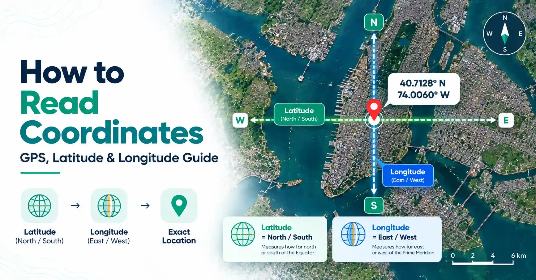
To read coordinates, start with the first number as latitude and the second as longitude when using the standard latitude-longitude order. Latitude shows a location's position north or south of the Equator. Longitude shows its position east or west of the Prime Meridian. The exact notation depends on the coordinate format.
For example:
40.7128, -74.0060
Here, 40.7128 is the latitude and -74.0060 is the longitude.
The positive latitude places the location north of the Equator. The negative longitude places it west of the Prime Meridian. These coordinates point to a location in New York City.
A simple rule to remember is:
Latitude first, longitude second.
What Are Latitude and Longitude?
Latitude and longitude form a geographic coordinate system that can describe positions on Earth. Each one measures a location from a different reference line.
What Is Latitude?
Latitude measures how far a location is north or south of the Equator. The Equator has a latitude of 0°.
Latitude ranges from 0° to 90° north and from 0° to 90° south. In decimal coordinates, positive latitude usually means north, while negative latitude means south.
For example, a latitude of 28.61° is north of the Equator. A latitude of -33.87° is south of it.
Lines of latitude run east to west around the Earth, but they measure north-south position.
What Is Longitude?
Longitude measures how far a location is east or west of the Prime Meridian, which is 0° longitude.
Longitude extends up to 180° east and 180° west. In decimal notation, positive longitude normally represents east, while negative longitude represents west.
For example, 77.21° longitude is east of the Prime Meridian, while -118.24° is west.
Lines of longitude run from pole to pole and are also known as meridians.
Which Comes First: Latitude or Longitude?
In the common geographic coordinate format, latitude usually comes first, followed by longitude.
The order is:
Latitude, Longitude
Consider these coordinates:
51.5074, -0.1278
51.5074 = latitude
-0.1278 = longitude
The first value places the location north of the Equator. The negative second value places it west of the Prime Meridian.
This order is common for GPS coordinates, but specialized mapping software and datasets may use a different coordinate order. Always check the specified coordinate system when working with GIS or professional spatial data.
How to Read GPS Coordinates
If you are learning how to read GPS coordinates, first identify their format. GPS coordinates commonly use latitude and longitude to represent a geographic position.
For example:
34.0522, -118.2437
The first value, 34.0522, is latitude. Because it is positive, the location is north of the Equator.
The second value, -118.2437, is longitude. The negative sign means the location is west of the Prime Meridian.
Some coordinates use letters instead of positive and negative signs. You might see N for north, S for south, E for east, and W for west.
For example, 34° N means north latitude, while 118° W means west longitude.
Understanding the Three Common Coordinate Formats
The same geographic location can be written in different ways. Three common formats are Decimal Degrees (DD), Degrees Minutes Seconds (DMS), and Degrees and Decimal Minutes (DDM).
1. Decimal Degrees (DD)
Decimal Degrees use decimal numbers to represent latitude and longitude.
Example:
40.7128, -74.0060
There are no minutes or seconds. The first number is latitude, and the second is longitude.
Negative signs indicate south for latitude and west for longitude. This clean format is common in GPS tools, digital maps, and online location services.
2. Degrees, Minutes and Seconds (DMS)
DMS divides each coordinate into degrees, minutes, and seconds.
Example:
40° 42' 46" N, 74° 0' 22" W
The symbols mean:
° = degrees
' = minutes
" = seconds
The letters identify direction. N means north, S means south, E means east, and W means west.
Unlike decimal notation, this format often uses direction letters rather than negative signs.
3. Degrees and Decimal Minutes (DDM)
Degrees and Decimal Minutes use degrees followed by minutes written as a decimal.
An example is:
40° 42.767' N, 74° 0.367' W
DDM sits between the other two formats. It uses whole degrees like DMS but expresses the remaining position with decimal minutes instead of separate minutes and seconds.
Recognizing the format is important before interpreting or entering coordinates.
How to Read Latitude and Longitude Coordinates
If you want to know how to read latitude and longitude coordinates, use a simple five-step process:
Identify the format. Check whether the coordinates use DD, DMS, or DDM.
Find the latitude. In the standard order, this is the first value.
Check north or south. A positive latitude is north, while a negative latitude is south.
Find the longitude. This is normally the second value.
Check east or west. Positive longitude is east, while negative longitude is west.
Take -33.8688, 151.2093 as an example.
The latitude is -33.8688, so the location is south of the Equator. The longitude is 151.2093, so it is east of the Prime Meridian. Together, the values identify a location in Sydney, Australia.
The same method helps when learning how to read lat and long coordinates in other decimal-based systems.
How to Read Coordinates on Google Maps
Learning how to read coordinates on Google Maps is easier once you understand decimal degrees. Coordinates shown by mapping services often use this format.
For example:
48.8566, 2.3522
The first number is latitude. Since 48.8566 is positive, the location is north of the Equator.
The second number is longitude. Since 2.3522 is positive, the location is east of the Prime Meridian.
If the first number were negative, it would indicate south. A negative second number would indicate west.
This means you can understand the general geographic position without relying only on a place name.
How to Read Map Coordinates
The phrase map coordinates does not always mean latitude and longitude. A map may use a geographic coordinate system or a grid-based projected coordinate system.
When learning how to read map coordinates, first check the map's coordinate system. Look at its legend, grid labels, units, and other reference information.
Some maps use degrees of latitude and longitude. Others may use coordinates measured in units such as meters.
Knowing the coordinate system prevents you from treating every pair of map numbers as latitude and longitude.
How to Read Land Survey Coordinates
Learning how to read land survey coordinates can require more information because surveys do not all use the same coordinate system.
A survey may use eastings and northings, bearings, reference points, or coordinates based on a local, state, national, or projected system. The survey may also specify a datum, which provides the reference framework used for the coordinates.
For example, an easting generally describes an east-west position within a grid, while a northing describes a north-south position.
If you need to know how to read survey coordinates for an official property boundary, check the coordinate system, datum, units, and survey notes. Professional survey information should be used when interpreting legal boundaries.
Common Mistakes When Reading Coordinates
Small mistakes can point to a completely different location. Watch for these common problems:
Reversing latitude and longitude: The first and second values have different meanings.
Missing a negative sign: Changing -74 to 74 moves a location from west to east.
Confusing direction letters: N and S refer to latitude, while E and W refer to longitude.
Mixing formats: DD, DMS, and DDM should not be read as if they use identical notation.
Using incomplete coordinates: Missing digits can reduce accuracy or identify the wrong place.
Assuming every grid is latitude and longitude: Survey and specialized maps may use other systems.
Ignoring the datum: Survey and GIS coordinates may depend on a specific reference framework.
Quick Example: Reading Coordinates Step by Step
Consider:
34.0522, -118.2437
Read it as follows:
34.0522 = latitude
Positive latitude = north
-118.2437 = longitude
Negative longitude = west
You can therefore tell that the location is north of the Equator and west of the Prime Meridian.
You do not need advanced GIS knowledge for basic coordinate reading. Identify the format, separate latitude from longitude, and then check the signs or direction letters.
Final Thoughts
Learning how to read coordinates becomes much simpler once you know the basic pattern. In standard latitude-longitude notation, latitude comes first and longitude comes second. Latitude tells you north or south, while longitude tells you east or west.
Next, identify whether the coordinates use decimal degrees, DMS, DDM, or another system. Pay close attention to negative signs and direction letters. For survey or specialized map coordinates, also check the stated coordinate system, datum, and units.
Frequently Asked Questions
Start by identifying the coordinate format. In standard latitude-longitude order, read the first value as latitude and the second as longitude. Latitude describes north-south position, while longitude describes east-west position. Then check negative signs or N, S, E, and W letters to determine the direction.
GPS coordinates commonly contain latitude and longitude values. Latitude shows how far north or south a location is relative to the Equator. Longitude shows its east-west position relative to the Prime Meridian. Together, the two numbers can identify a geographic location.
In standard latitude-longitude notation, the first number is latitude and the second is longitude. For example, in 25.2048, 55.2708, 25.2048 is the latitude and 55.2708 is the longitude. Both positive values indicate a position north of the Equator and east of the Prime Meridian.
A negative latitude indicates a location south of the Equator, while a negative longitude indicates a location west of the Prime Meridian. Positive latitude generally means north, and positive longitude means east. For example, -23.5, -46.6 represents a position in the Southern and Western Hemispheres.
Decimal Degrees are often straightforward for beginners because each coordinate is written as one decimal number. For example, 40.7128, -74.0060 contains only two main values. Other formats, such as DMS, can also be easy to read once you understand degrees, minutes, seconds, and direction letters.
GPS coordinates commonly use latitude and longitude to describe a location, so the terms are often used together in everyday mapping. However, coordinate data can be represented in different formats and reference systems. Latitude and longitude specifically describe geographic position in angular terms.