




Learn what is a map projection, how map projections work, their main types, common uses, and how shape, area, distance, and direction distortion occurs.
Maps help us understand where places are, how far apart they are, and how land and water are arranged. But making an accurate map is not as simple as copying the Earth onto paper or a screen. The Earth is curved, while most maps are flat.
This difference creates a basic challenge for mapmakers. A curved surface cannot be flattened without changing some part of its shape, size, distance, or direction. A map projection provides a mathematical way to handle this problem.
Understanding projections can help you read maps more accurately and choose suitable maps for navigation, GIS, land mapping, education, and other geographic tasks.
What Is a Map Projection?
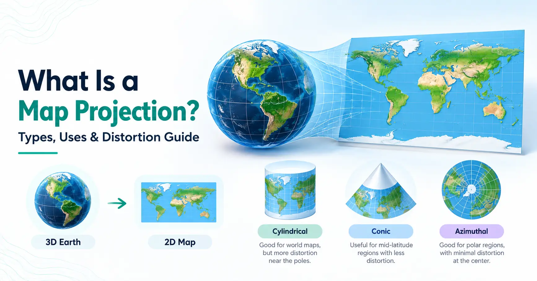
A map projection is a mathematical method used to represent the curved surface of the Earth on a flat map. It converts locations based on latitude and longitude into positions on a two-dimensional surface. During this process, some distortion of shape, area, distance, or direction is unavoidable.
In simple terms, the map projection meaning is about turning a round Earth into a flat view.
If you need a basic definition of projection map, think of it as a system that decides where points on the Earth should appear on a flat map. The formulas used depend on what the map needs to show accurately.
So, when people ask what is a projection map, the key idea is the same: it is a way to display the Earth's curved surface in two dimensions.
Why Do We Need Map Projections?
The Earth is roughly spherical, but paper maps, computer screens, and printed atlases are flat. You cannot flatten a curved surface perfectly without changing it.
Imagine peeling an orange and trying to press the peel flat on a table. The peel may tear, stretch, overlap, or change shape. A similar problem occurs when the Earth's surface is shown on a flat map.
Map projections provide controlled ways to manage these changes. Instead of trying to remove distortion completely, mapmakers choose which properties matter most for a particular purpose.
For example, one projection may be useful for navigation because it handles direction in a helpful way. Another may preserve area better, making it more suitable for comparing the sizes of regions.
This is why map projections are important in GIS, surveying, navigation, education, land management, spatial analysis, and cartography.
How Does a Map Projection Work?
A map projection uses mathematical formulas to move geographic locations from the curved Earth onto a flat coordinate system.
The basic process can be understood as:
Earth's curved surface → latitude and longitude → mathematical transformation → flat map
Latitude tells us how far north or south a location is from the Equator. Longitude shows how far east or west it is from the Prime Meridian.
Projection formulas take these geographic coordinates and calculate where each location should appear on a flat surface.
Different formulas produce different results. That is why the same continent can look slightly different on two world maps even though both maps show the same real location.
What Are the Main Types of Map Projections?
If you are wondering what are map projections, there is no single design. Projections can be grouped according to the surface or method used to transfer geographic information.
Three common groups are cylindrical, conic, and azimuthal projections. Compromise projections are also widely used when a balanced world view is needed.
Cylindrical Projection
A cylindrical projection can be pictured as placing a cylinder around the Earth and transferring locations onto that surface. The cylinder is then opened into a flat rectangle.
The Mercator projection is a well-known example. It became useful for navigation because lines of constant compass direction appear straight. However, area distortion increases toward the poles.
As a result, places at high latitudes can appear much larger than their true size compared with regions near the Equator.
Conic Projection
A conic projection can be imagined by placing a cone over part of the Earth and projecting locations onto it. When the cone is opened, it forms a flat map.
Conic projections are often useful for mapping areas that extend mainly from east to west, especially across the middle latitudes.
Distortion can be kept relatively low along selected lines where the cone and globe meet. It usually increases farther away from those areas.
Azimuthal or Planar Projection
An azimuthal projection, also called a planar projection, transfers locations onto a flat plane that touches or cuts through the globe.
These projections are often centered on one location. Depending on the specific projection, they can preserve useful properties such as direction or distance from that central point.
They are commonly associated with maps of polar regions because a flat plane can be positioned over a pole effectively.
Compromise Projections
Some world maps are designed to avoid extreme distortion rather than preserve one property exactly. These are called compromise projections.
The Robinson projection is a familiar example. It balances the appearance of area, shape, and distance to create a visually useful view of the world.
A compromise projection does not remove distortion. Instead, it spreads distortion across the map so that no single type becomes too dominant.
What Is Map Distortion?
Map distortion is the change in geographic properties that occurs when the Earth's curved surface is represented on a flat map.
Every flat map of the whole Earth contains some distortion. A projection can preserve certain properties well, but it cannot keep shape, area, distance, and direction perfectly accurate everywhere at the same time.
The Four Main Types of Map Distortion
1. Shape distortion: The outline or form of a country, continent, or other feature may appear stretched or compressed.
2. Area distortion: A region may appear larger or smaller compared with its actual area on Earth.
3. Distance distortion: The space between two locations may not match the same scale across every part of a map.
4. Direction distortion: The direction from one location to another may change depending on the projection and where the locations are positioned.
Understanding these differences helps explain why two accurate maps can still look different.
Why Do Different Map Projections Look Different?
Different projections look different because each one handles the curved Earth in its own way.
One projection may focus on preserving local shapes. Another may focus on keeping relative areas accurate. A third may be designed around direction or distance from a specific point.
These choices affect how geographic features appear. Countries near the poles, for example, can look much larger on some projections than on others.
This does not always mean the map is incorrect. It means the projection was designed with a particular purpose and set of trade-offs.
Common Uses of Map Projections
Map projections are used wherever geographic information needs to appear on a flat surface. Their practical uses include:
Navigation: Certain projections help display routes and directions in useful ways.
GIS and spatial analysis: GIS software uses coordinate systems and projections to display, measure, and analyze spatial data.
Land and regional mapping: Suitable projections help map specific regions with controlled distortion.
Weather and climate maps: Geographic data can be displayed across countries, continents, or the globe.
Education: Classroom maps use projections to explain countries, oceans, continents, and geographic patterns.
World maps: Compromise and other projections provide different ways to display the entire Earth.
Transportation planning: Projected maps can support route planning and geographic analysis.
The intended use of a map often determines which projection is suitable.
How to Choose the Right Map Projection
There is no single map projection that works best for every task. The right choice depends on what you need to map and what measurements or visual properties matter most.
Important factors include the geographic area, map purpose, scale, location, and the need to preserve area, shape, distance, or direction.
For example, a map designed to compare the sizes of regions may benefit from an equal-area projection. A navigation map may place greater importance on direction.
The size of the mapped region also matters. A projection suitable for the entire world may not be the best choice for a city, state, or individual land area.
Before selecting a projection, ask a simple question: What information must this map represent most accurately?
That answer can guide the choice.
Map Projection vs Geographic Coordinate System
A geographic coordinate system and a map projection are related, but they are not the same thing.
A geographic coordinate system uses coordinates such as latitude and longitude to describe positions on the Earth's curved surface.
A projected coordinate system uses a map projection to transform those locations into flat coordinates. These coordinates can then be displayed and, when an appropriate projected system is used, support measurements and spatial analysis on a map.
In short, latitude and longitude describe geographic positions, while a projection determines how those positions appear on a flat surface.
Final Thoughts
So, what is a map projection? It is the mathematical bridge between the curved Earth and a flat map. Because the Earth cannot be flattened perfectly, every projection involves trade-offs.
Learning how projections work makes it easier to understand why maps can show the same places in different shapes or sizes. It also helps you choose maps more carefully for navigation, GIS, land mapping, education, and geographic analysis. The most useful projection depends on the area being mapped and the information that needs to remain accurate.
Frequently Asked Questions
A map projection is a method for showing the curved surface of the Earth on a flat map. It converts geographic locations into two-dimensional positions. Because a curved surface cannot be flattened perfectly, every projection changes some combination of shape, area, distance, or direction.
The three common types are cylindrical, conic, and azimuthal projections. Cylindrical projections transfer locations onto a cylinder, conic projections use a cone, and azimuthal projections use a flat plane. Each approach creates different patterns of distortion and works well for different mapping needs.
Map projections are necessary because the Earth is curved while most maps are flat. A projection provides a mathematical method for converting locations on the Earth's surface into positions that can be displayed on paper or a screen.
The four main types are shape, area, distance, and direction distortion. A projection may preserve one of these properties better than another, but no flat world map can keep all four perfectly accurate everywhere.
No flat map can represent the entire curved surface of the Earth without distortion. Flattening a curved surface always changes some geographic properties. Different map projections manage this problem by preserving certain properties or balancing several types of distortion.
It depends on the purpose of the map. The Mercator projection is widely recognized and has long been important for navigation. Other projections are more suitable when accurate area, regional mapping, polar mapping, or a balanced view of the world is the main goal.