




What is latitude and longitude? Learn how GPS coordinates work, how to read them, and why they matter for mapping, surveying, construction, and land measurement.
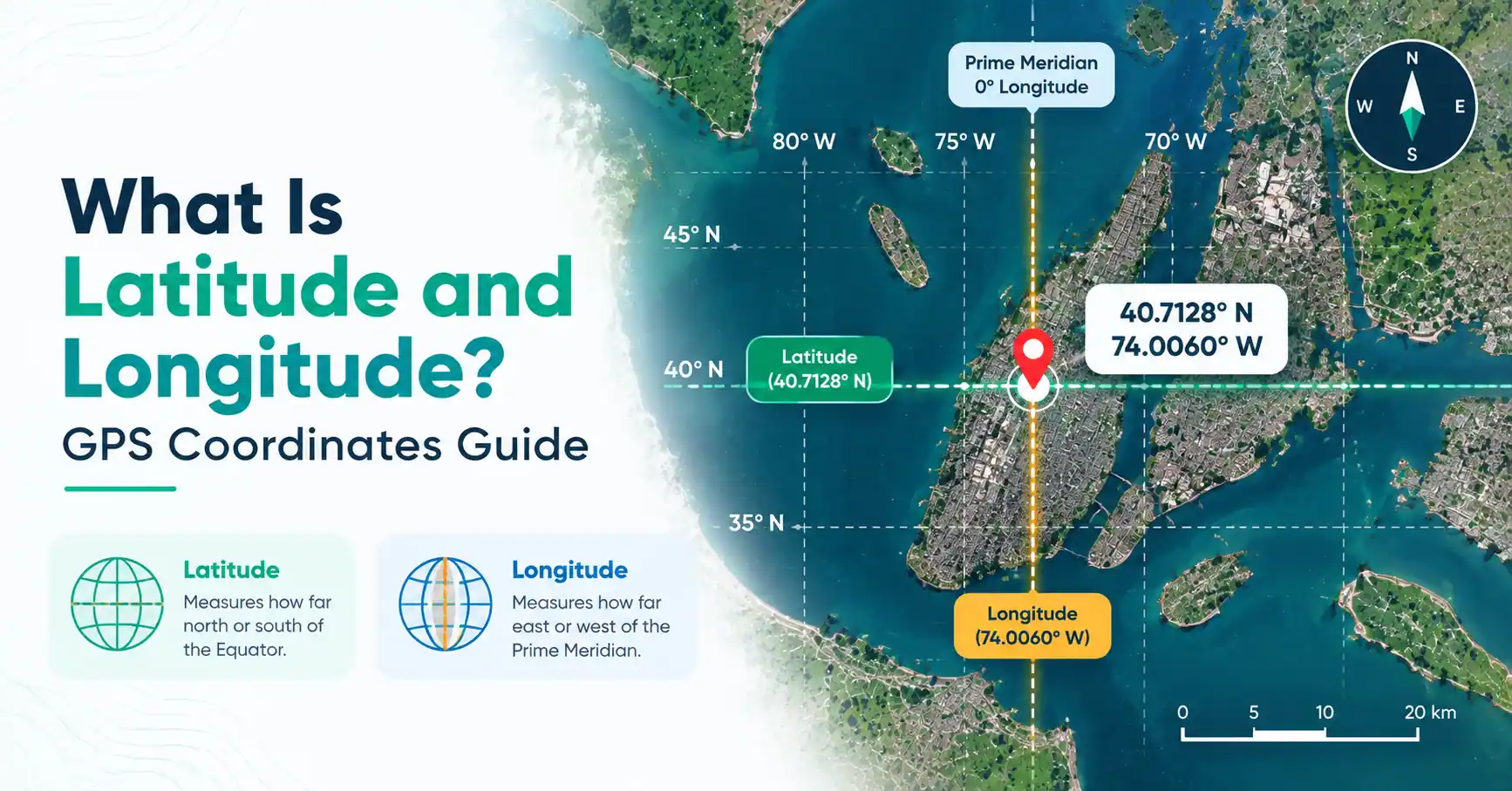
If you have ever looked at a GPS location such as 40.7128° N, 74.0060° W, you have already seen latitude and longitude in action. These two values work together like a global addressing system, allowing a point on Earth to be described with numbers instead of only a street name, landmark, or property description. Understanding what is latitude and longitude is useful for anyone working with maps, GPS, surveying, construction, or land measurement.
Latitude and longitude are especially useful when a location needs to be recorded accurately. A surveyor can save the position of a field point, a construction team can mark a site location, and a property planner can connect a land parcel to a digital map. GPS devices and mapping tools use these coordinates to turn a physical location into information that can be stored, measured, and shared.
What Is Latitude and Longitude?
Latitude and longitude are two parts of a geographic coordinate system. Together, they describe where a particular point is located on Earth. Latitude gives the point's position relative to the Equator, while longitude gives its position relative to the Prime Meridian.
Imagine placing a large numbered grid around the Earth. One set of lines helps you move north or south, and the other helps you move east or west. Where the two positions meet is the location you are looking for.
Coordinates are normally written as:
Latitude, Longitude
For example:
40.7128° N, 74.0060° W
The first number represents latitude and the second represents longitude. The letters tell you which side of the reference line the location is on.
This system is used by GPS receivers, digital maps, surveying equipment, navigation applications, and geographic information systems.
What Is Latitude?
Latitude describes how far a location is positioned north or south of the Equator. The Equator is the starting reference at 0° latitude. Moving toward either pole increases the latitude value until reaching 90°.
A location can therefore be described as being north or south of the Equator. For example, 28° N means the point is north of the Equator, while 28° S means it is south.
Latitude lines are commonly shown as horizontal lines when looking at a standard world map. They are useful for understanding the north-south position of a location.
For GPS and land measurement, latitude becomes useful when a specific field point, property, or construction site needs to be identified. By itself, however, latitude is not enough to locate a unique point because many places can share the same latitude.
What Is Longitude?
Longitude describes a location's position east or west of the Prime Meridian. The Prime Meridian is used as the 0° longitude reference. Longitude values continue in both directions until reaching 180°.
For example, 75° W describes a position west of the Prime Meridian, while 75° E describes one east of it.
Longitude lines run between the North and South Poles. When displayed on a map, they may appear vertical or curved depending on the map projection.
Longitude becomes much more useful when paired with latitude. A longitude value tells you the east-west position, but the latitude tells you where the point sits north or south. Together, they narrow the location down to a specific geographic point.
What Is the Difference Between Latitude and Longitude?
The simplest answer to what is the difference between latitude and longitude is that they measure position in two different directions. Latitude identifies the north-south position of a point, while longitude identifies its east-west position.
Feature | Latitude | Longitude |
| Main purpose | Shows north or south position | Shows east or west position |
| Reference | Equator | Prime Meridian |
| Starting value | 0° | 0° |
| Maximum | 90° N or S | 180° E or W |
| Example | 40.7128° N | 74.0060° W |
A useful way to remember the difference is to think about the two measurements as two instructions. Latitude tells you which north-south band you are in, and longitude tells you which east-west position you are in.
How Do Latitude and Longitude Work Together?
One coordinate value cannot normally identify an exact location. You need both measurements to narrow down the position.
Take this example:
40.7128° N, 74.0060° W
The latitude places the point north of the Equator. The longitude places it west of the Prime Meridian. When those two positions are combined, they describe a particular point on the Earth's surface.
This becomes particularly useful in fieldwork. Instead of describing a survey point as "near the northern boundary," a team can record its geographic coordinates and return to that position using suitable GPS or surveying equipment.
Several coordinate points can also be collected to represent features across a site, such as survey locations, access points, or mapped boundaries.
How Are Latitude and Longitude Used in GPS?
GPS uses signals received from satellites to determine a device's position. The resulting location can be represented using latitude and longitude and displayed on a digital map.
For everyday navigation, this might simply mean seeing a moving position marker on your phone. In professional work, the same concept can support more detailed location-based tasks.
Construction professionals can use coordinate information to identify site positions. Surveyors can record field points, while land measurement users can connect GPS locations with mapping and area calculations.
GPS coordinates can support:
- Field location recording
- Land measurement
- Surveying
- Construction site positioning
- Property mapping
- Navigation
The level of accuracy required depends on the task. A general navigation location and a legal property boundary survey do not necessarily require the same equipment or measurement process.
How to Read Latitude and Longitude Coordinates
Latitude and longitude can be displayed in several formats. Two common formats are decimal degrees and degrees, minutes, and seconds (DMS).
A decimal coordinate might look like:
40.7128° N, 74.0060° W
The degree symbol indicates that the values are expressed as angular measurements. The N and W identify the directions.
Coordinates can also be written using positive and negative values. Depending on the coordinate convention, north and east are generally represented by positive values, while south and west are represented by negative values.
For example:
40.7128, -74.0060
represents the same general location as 40.7128° N, 74.0060° W.
When entering coordinates into a mapping or GPS tool, check the expected format. Reversing latitude and longitude or using the wrong direction can produce a completely different location.
How to Find the Latitude and Longitude of a Location
Finding the coordinates of a location is usually straightforward with modern digital tools. You can use a GPS receiver, smartphone location service, digital map, or an online coordinate tool.
For a general location, search for the place on a digital map and select the required point. The map can then provide the latitude and longitude associated with that position.
For land measurement, however, the exact point matters. A large property can contain many different coordinate positions, so using the coordinates of a nearby town or city is not enough for detailed site work.
Surveyors may collect coordinates directly in the field. These points can later be used to create maps, record boundaries, or connect field measurements with digital geographic data.
What Is the Latitude and Longitude of New York City?
A commonly used representative coordinate for New York City is approximately 40.7128° N, 74.0060° W.
This is useful as a general example when learning how coordinates work. It should not be treated as the exact coordinate of every location in New York City because the city covers a large area.
A particular building, street, property, or survey point within the city will have its own latitude and longitude. For accurate mapping, always use coordinates for the exact point being measured.
What Is the Latitude and Longitude of Canton, Ohio?
Canton, Ohio is located at approximately 40.8° N, 81.37° W. A more specific representative position is around 40.805° N, 81.376° W.
As with New York City, these values should be understood as a representative location rather than a single coordinate for every point within Canton. The exact coordinates will change depending on the location being measured.
This distinction matters when using location data for surveying or property work. A city-level coordinate can identify the general area, while a site-specific coordinate is needed for detailed field measurement.
Why Latitude and Longitude Matter for Land Measurement
Geographic coordinates give land measurement users a consistent way to identify points on a map. Instead of relying only on a property name or nearby landmark, a coordinate provides a numerical description of a location.
For example, survey teams can record the positions of important field points and use those points as part of a larger mapping workflow. Construction teams can also use coordinate information to connect site locations with digital plans.
Coordinates are particularly useful when working across large areas. They make it easier to organize location data, compare field observations, and connect physical sites with digital mapping systems.
However, coordinates are only one part of professional land measurement. Accurate boundary work may also require distances, bearings, control points, specialized equipment, and professional surveying procedures.
Latitude, Longitude, and Land Surveying
Surveyors use geographic coordinates to establish and record positions on land. Depending on the project, these coordinates may be collected using GPS equipment, total stations, or other surveying instruments.
A coordinate identifies a position, but it does not automatically define a legal property boundary. To establish a boundary, surveyors may need to combine coordinates with measured distances, bearings, existing records, and other evidence.
For construction projects, coordinate data can help connect field locations with site plans and digital mapping. This creates a useful link between what is measured on the ground and what is represented on a computer or map.
Common Mistakes When Reading Coordinates
Several simple mistakes can lead to an incorrect location:
- Mixing up latitude and longitude
- Entering longitude before latitude when the tool expects the opposite order
- Ignoring N, S, E, and W directions
- Confusing decimal degrees with DMS coordinates
- Assuming an entire city has one exact coordinate
- Using incorrect positive or negative signs
Always check the coordinate format before using location data. This is especially important when transferring coordinates between GPS devices, spreadsheets, mapping applications, and surveying software.
Conclusion
Understanding what is latitude and longitude gives you a practical foundation for working with GPS, maps, surveying, and land measurement. Latitude describes a point's north-south position, while longitude describes its east-west position. Together, they create a geographic coordinate that can identify a location on Earth. For construction professionals and surveyors, coordinates can connect field measurements with digital maps and site plans. For everyday users, they make navigation and location searches easier. The key is to use the correct coordinate format and remember that a city or property can contain many different coordinate points.
Frequently Asked Questions
Latitude and longitude are two measurements used together to describe a location on Earth. Latitude identifies the position north or south of the Equator, while longitude identifies the position east or west of the Prime Meridian.
Latitude describes north-south position, while longitude describes east-west position. They use different reference lines and must generally be combined to identify a specific geographic point.
Latitude is the measurement used to describe a location's position north or south of the Equator. Longitude describes its position east or west of the Prime Meridian.
The two values work together as a coordinate. Latitude narrows the position from north to south, while longitude narrows it from east to west, allowing a particular point to be identified.
GPS determines a receiver's geographic position using satellite signals. That position can then be expressed as latitude and longitude and displayed on a digital map.
A commonly used representative coordinate for New York City is approximately 40.7128° N, 74.0060° W. The exact coordinates vary depending on the point within the city.
Canton, Ohio is approximately 40.8° N, 81.37° W. The exact coordinate depends on the particular point being referenced within the city.
Coordinates are normally read as latitude first and longitude second. Check the numbers, direction letters, and coordinate format before entering them into a GPS or mapping tool.
Latitude normally comes first, followed by longitude. For example, 40.7128° N, 74.0060° W lists the latitude first and longitude second.
They provide a consistent way to record geographic positions. Surveyors can combine coordinate data with distances, bearings, and other measurements to map land and support construction or property planning.