




When was GPS invented, and who made it possible? Explore the history of GPS, from early satellite experiments and military development to public access, car navigation, smartphones, and modern GPS watches.
You open a map on your phone, enter an address, and follow the directions. A small dot moves along the road as you travel. It feels simple, but the technology behind that dot took decades to build.
So, when was gps invented, and how did it become part of everyday life?
GPS began as a U.S. military project designed to help people and equipment find their positions. It grew from early satellite experiments into a worldwide navigation system. Along the way, researchers developed new ways to measure distance, track satellites, and send accurate timing signals from space.
When Was GPS Invented?
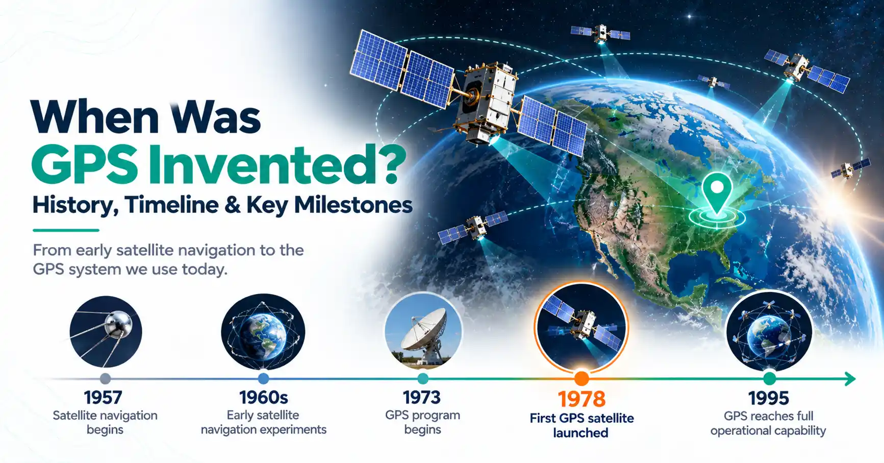
Modern GPS development began in 1973 under the U.S. Department of Defense. The first experimental NAVSTAR GPS satellite launched in 1978. GPS reached initial operational capability in 1993 and full operational capability in 1995. These milestones show that the system took more than 20 years to develop.
To understand when the gps was invented, it helps to separate the start of the project from the completion of the satellite network.
The military wanted reliable navigation across oceans, deserts, and remote areas. Unlike older methods, GPS could provide positioning information without requiring users to identify nearby landmarks.
What Does GPS Stand For?
If you have wondered what does g.p.s. stand for, the answer is Global Positioning System.
GPS is a satellite navigation system that provides position and time information. It uses radio signals sent by satellites orbiting Earth.
A receiver, such as a phone or navigation device, compares signals from several satellites. These measurements help it work out where it is.
GPS does not create road maps. Instead, mapping software uses GPS location data to show your position on a digital map.
The technology also supports land surveying, farming, outdoor activities, vehicle tracking, and accurate timekeeping.
Who Invented GPS?
The question who invented the gps cannot be answered with just one name. Several scientists, engineers, and military teams helped turn satellite navigation ideas into a working system.
Three contributors played major roles.
Bradford Parkinson helped lead the NAVSTAR GPS program during the 1970s. His leadership helped bring different navigation technologies together into a unified system.
Ivan Getting supported the development of satellite-based positioning concepts. His work helped shape ideas that later influenced GPS.
Roger Easton developed important satellite tracking and timing technologies. Accurate timing became one of the foundations of GPS positioning.
Their work was supported by many other researchers who designed satellites, receivers, clocks, and control systems.
Rather than being the invention of one person, GPS grew through years of shared research and engineering.
When Was GPS Discovered?
People sometimes search for when was gps discovered, but GPS was developed rather than discovered. Its history began with research into how moving satellites could help determine locations on Earth.
In 1957, the Soviet Union launched Sputnik, the first artificial satellite.
Researchers noticed that the frequency of Sputnik's radio signals changed as it moved through the sky. This effect, known as the Doppler effect, helped scientists study the satellite's movement.
They later explored the reverse idea: if a satellite's location was known, could its signals help determine a receiver's position?
That research contributed to TRANSIT, an early satellite navigation system used by the U.S. Navy.
TRANSIT could provide location fixes, but it did not offer the continuous navigation service that modern GPS provides.
These experiments created an important foundation for later satellite positioning technology.
When Was the GPS Developed? Key Historical Milestones
For anyone asking when was the gps developed, the modern program began in 1973. However, several earlier discoveries and later improvements were needed before GPS became widely useful.
The following timeline shows its major milestones.
Year | GPS history milestone |
| 1957 | Sputnik launches and inspires satellite tracking research |
| 1960s | TRANSIT and other early navigation systems develop |
| 1973 | The NAVSTAR GPS program begins |
| 1978 | The first experimental GPS satellite launches |
| 1983 | The U.S. announces plans for civilian GPS access |
| 1993 | GPS reaches initial operational capability |
| 1995 | GPS reaches full operational capability |
| 2000 | Selective Availability is switched off |
| 2000s | GPS spreads through car navigation and mobile devices |
| 2010s onward | GPS becomes common in smartphones and wearable technology |
Each stage solved a different problem. Early experiments proved that satellite positioning could work. Later satellites improved coverage, while better receivers made the technology easier to use.
When Did GPS Become Available to the Public?
The U.S. government announced plans for civilian GPS access in 1983. The decision followed the destruction of Korean Air Lines Flight 007 after the aircraft entered restricted Soviet airspace.
However, the announcement did not mean that a complete GPS service was immediately available.
The satellite network was still under development. Civilian receivers became more useful as additional satellites entered service.
By 1995, GPS had reached full operational capability.
Another important change came in May 2000, when the United States switched off Selective Availability.
This feature had deliberately reduced the accuracy of standard civilian GPS signals. Removing it improved positioning accuracy for ordinary users.
The change helped make GPS more practical for navigation, mapping, and outdoor activities.
When Was GPS First Used in Cars?
GPS-based navigation began appearing in production cars during the early 1990s.
Before GPS became common, some vehicles already had electronic navigation systems. These relied on sensors, stored maps, or other methods rather than satellite signals.
GPS changed how these systems worked. A receiver could calculate the vehicle's location using signals from satellites.
Digital maps could then display the car's position and help drivers follow a route.
During the 2000s, portable GPS navigation devices became popular. Drivers could mount a small screen on the dashboard and receive directions while traveling.
Later, smartphones made separate navigation devices less necessary for many drivers.
Today, GPS is widely used in built-in vehicle systems, mobile navigation apps, and fleet tracking.
When Did Cell Phones Get GPS?
GPS-enabled mobile phones began appearing around the late 1990s and early 2000s. The feature did not arrive on every phone at the same time.
Early location-enabled phones offered basic services, including emergency positioning and limited navigation.
By 2003, GPS was already an established technology. It was used in cars, handheld navigation devices, professional equipment, and some mobile phones.
As mobile hardware improved, manufacturers began adding better location features.
Smartphones later combined satellite positioning with digital maps, mobile internet, and search tools.
This allowed users to find nearby businesses, follow walking directions, and share their locations.
Modern smartphones may also use signals from several satellite navigation systems rather than GPS alone.
How Did GPS Watches Become Popular?
GPS technology eventually became small enough to fit into wearable devices.
Early GPS watches were especially useful for runners, cyclists, hikers, and other outdoor users.
A global positioning system watch can record movement using satellite signals. Depending on the device, it may track distance, speed, pace, and travel routes.
For example, a runner can measure a five-kilometer route without manually checking the distance on a map.
GPS watches also help hikers record trails and review their journeys.
As batteries and satellite receivers improved, these features became common in fitness watches and smartwatches.
Many models can now record outdoor activities without a connected phone, although capabilities vary.
Who Owns and Operates GPS Today?
The United States government owns GPS, and the U.S. Space Force operates and maintains its satellite constellation.
Although GPS is available to civilian users worldwide, it remains a U.S.-operated system.
Other countries and regions have developed their own satellite navigation networks.
GLONASS is Russia's satellite navigation system.
BeiDou is China's satellite navigation system.
Galileo is operated by the European Union.
Together with GPS, these systems belong to the wider category known as Global Navigation Satellite Systems, or GNSS.
Many modern receivers can use signals from multiple constellations. This helps provide more positioning options, especially where buildings or terrain block parts of the sky.
How Many GPS Satellites Are There?
GPS was designed around a basic constellation of 24 satellites. However, the operational network can contain more satellites to support coverage and reliability.
The exact number changes as satellites are launched, replaced, or taken out of service.
A GPS receiver generally needs signals from at least four satellites to calculate a three-dimensional position and correct its clock.
Each satellite sends precise timing and orbital information. The receiver uses those signals to estimate its distance from the satellites.
Ground control stations also monitor the network and help maintain accurate navigation data.
For an updated satellite count, the official U.S. GPS website provides constellation information.
How Has GPS Changed Everyday Life?
GPS supports many activities beyond driving directions.
Farmers use positioning systems to guide equipment and manage fields. Surveyors use specialized GPS receivers to measure land and record coordinates.
Delivery companies use location information to follow vehicles and organize routes.
Hikers, cyclists, and travelers can record their journeys or find their way through unfamiliar areas.
Emergency services also use location data to help coordinate responses.
GPS provides accurate timing as well. Communication networks and other infrastructure depend on precise time signals.
Although many people know GPS through mobile maps, its applications extend far beyond navigation.
Final Thoughts
GPS development began in 1973, following years of satellite research. Bradford Parkinson, Ivan Getting, Roger Easton, and many other researchers contributed to its progress.
The first experimental NAVSTAR GPS satellite launched in 1978, and the system became fully operational in 1995. Civilian use expanded further after Selective Availability ended in 2000.
What started as a military navigation project eventually became part of cars, smartphones, watches, and professional equipment. GPS history shows how decades of research helped make reliable positioning available around the world.
Frequently Asked Questions
The United States announced plans for civilian GPS access in 1983. However, the satellite network was still being developed. GPS reached full operational capability in 1995, and civilian accuracy improved significantly after Selective Availability was switched off in 2000.
Yes. GPS existed well before 1993. The modern program began in 1973, and experimental satellites launched during the following years. In 1993, GPS reached initial operational capability. Full operational capability followed in 1995, completing an important stage of its development.
Yes. GPS was already operational in 2003. It was used in car navigation, handheld receivers, surveying equipment, and some mobile devices. Civilian positioning had also improved after the removal of Selective Availability in 2000, making GPS more useful for everyday navigation.
GPS-enabled mobile phones began appearing in the late 1990s and early 2000s. There was no single worldwide launch year because manufacturers introduced the feature at different times. GPS became much more common as smartphones and location-based applications developed.
Russia operates GLONASS, while China operates BeiDou. Both provide satellite-based positioning and timing services. Many modern smartphones and navigation receivers can use signals from GPS, GLONASS, BeiDou, and Galileo, allowing them to work with more than one satellite navigation network.
The original GPS constellation was designed around 24 satellites, but the operational network usually includes additional satellites. The exact number changes as satellites enter or leave service. For the latest count, check official GPS constellation updates published by the U.S. government.