



Looking for a home near work, school, or essential services? Learn how to use a real estate radius map to find nearby properties, draw a radius around an address, compare travel distances, and choose the right search area.
Finding a home near work, school, or family can take hours of searching. You may find a great house, only to discover that it is too far from the places you visit most.
A real estate radius map can make your search easier. It shows a circular area around a chosen location, such as an office or school.
You can use it to focus on homes within 2, 5, or 10 miles of that point. However, radius distance is measured in a straight line, not along roads.
This guide explains how radius maps work, how to search for nearby properties, and how to compare locations.
What Is a Real Estate Radius Map?
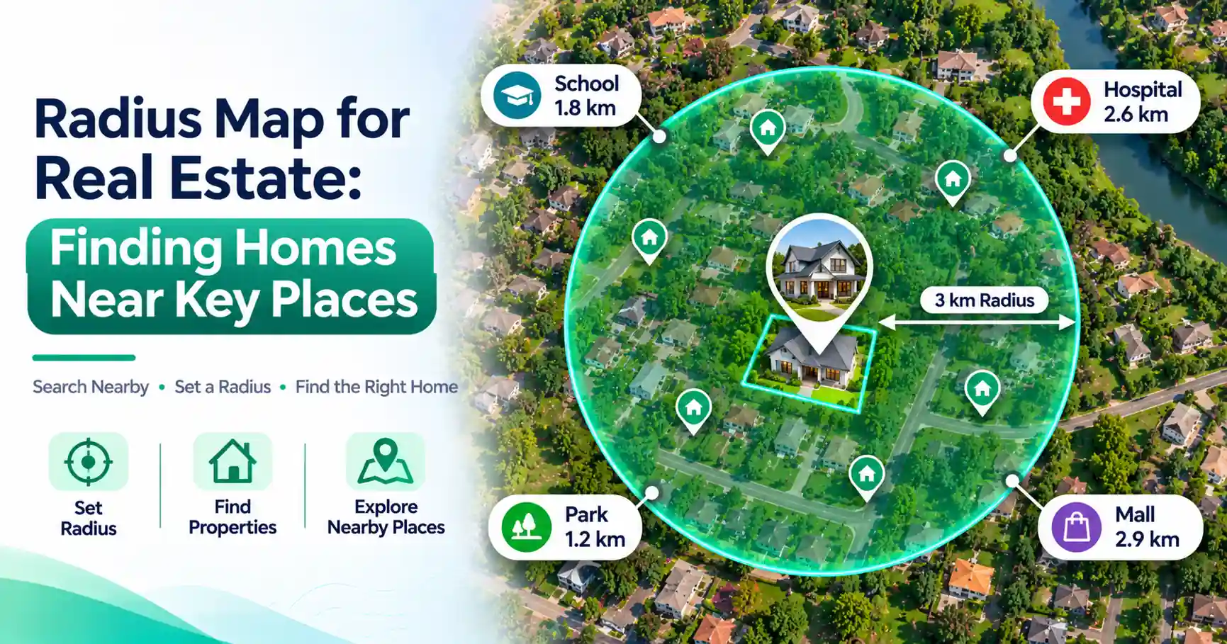
A real estate radius map shows a circular area around a selected location. The circle represents a set straight-line distance, such as 2, 5, or 10 miles. Buyers and renters can use this area to explore neighborhoods and find properties near places that matter to them.
A property radius map has three main parts:
- Center point: The location you want to search around.
- Radius distance: The distance from the center to the circle's edge.
- Search area: The land covered by the circle.
For example, you might draw a 5-mile radius around your office to explore nearby neighborhoods.
The circle shows geographic distance. It does not show how far you must drive.
How Does a Radius Map Work for Property Searches?
A radius map uses a central location and a chosen distance to define a circular search area.
You can place the center on a school, office, hospital, or street address.
After selecting a radius, the map shows which areas fall within that distance.
You can then review nearby neighborhoods and compare available property listings.
For example, a 3-mile radius around a school includes locations no more than 3 miles away in a straight line.
However, a home inside that circle might require a longer road trip.
Also, not every radius mapping tool displays homes for sale. Some tools only draw circles, so you must check property listings separately.
How to Find Homes Within a Certain Radius
You can find homes within a certain radius by defining a search area and reviewing available listings inside it.
Follow these six steps to use a radius map for property search.
Step 1: Choose Your Starting Location
Decide which place matters most.
It could be your workplace, a school, a hospital, or a family member's home.
This location becomes the center of your search.
Step 2: Enter the Address
Enter the full address into a radius mapping tool.
You may also be able to select a point directly on the map.
Check that the center appears in the correct place.
Step 3: Set the Radius Distance
Choose a distance that matches your needs.
For example, start with a 5-mile radius if you want to explore several nearby neighborhoods.
You can increase or reduce the distance later.
Step 4: Review the Search Area
Look at the neighborhoods, streets, and residential areas inside the circle.
Check whether the search area includes places you would consider living.
Step 5: Find Available Property Listings
Review homes for sale or rent within the selected area.
A general radius tool may not display listings, so you may need a separate property search service.
Step 6: Compare the Properties
Compare property prices, sizes, conditions, and locations.
Check actual travel routes before deciding which homes deserve a closer look.
A radius map narrows your options, but it does not replace detailed property research.
How to Map a Radius Around an Address
You can map radius around an address using an online radius mapping tool.
The process is simple:
- Open a map radius tool.
- Enter the street address.
- Select the correct location.
- Choose a distance in miles or kilometers.
- Display the radius circle.
- Explore the surrounding area.
For example, imagine you work in an office downtown.
You enter the office address and draw a 3-mile circle.
The map highlights nearby areas where you can begin looking for homes.
Keep in mind that some mapping systems place an address at an estimated point rather than the exact entrance.
Check the center before relying on the result.
How to Find Properties Near Schools Using a Radius Map
Families often search for properties near schools to make daily travel easier.
A radius map can help identify neighborhoods around a chosen school.
For example, you could draw a 2-mile radius around an elementary school and review available homes inside the circle.
You can also compare search areas around several schools.
This approach may help you find neighborhoods with shorter potential trips to school.
However, living close to a school does not guarantee enrollment.
School attendance zones are different from radius circles.
A home one mile away may fall outside the school's assigned attendance area, while a more distant home may fall inside it.
School boundaries can also change.
Always confirm enrollment rules and attendance zones with the relevant school district before buying a home.
Finding Homes Near Workplaces, Hospitals, and Other Key Places
A radius map is useful for more than school searches.
You can explore homes near several important destinations.
Homes Near Workplaces
Place the radius center at your office or workplace.
Review neighborhoods within your chosen distance.
Then compare driving routes, traffic conditions, and travel times.
A nearby home does not always offer the shortest commute.
Homes Near Hospitals
If access to medical services matters, draw a circle around a hospital.
Identify nearby residential areas and check available properties.
Remember that road access may affect how quickly you can reach the hospital.
Homes Near Grocery Stores
You can also explore neighborhoods near grocery stores, shopping centers, and other daily services.
This helps you compare convenience before visiting properties.
Homes Near Parks and Public Transportation
A radius map can highlight residential areas near parks, train stations, or bus stops.
Check walking routes and transit schedules when these features are important to your search.
Radius Distance vs Driving Distance: What's the Difference?
Radius distance is the straight-line distance between two locations.
Driving distance follows roads and permitted travel routes.
These measurements are not the same.
Factor | Radius Distance | Driving Distance |
| Measurement | Straight line | Road route |
| Road layout | Not considered | Considered |
| Traffic | Not included | Affects travel time |
| Best use | Geographic search | Trip planning |
| Common use | Finding nearby neighborhoods | Comparing commutes |
For example, a home might be 3 miles from your workplace in a straight line.
However, a river or highway could make the driving route much longer.
Walking and public transit routes may differ from driving routes as well.
Use radius distance to narrow your search. Use route distance and travel time to compare daily trips.
How to Measure Distance From Property to Amenities
The distance from property to amenities can affect how convenient a location feels.
Amenities may include schools, parks, hospitals, grocery stores, and public transportation.
To compare distances:
- Identify the property's location.
- Select the amenity you want to reach.
- Check the straight-line distance.
- Review the actual road or walking route.
- Compare travel times when needed.
For example, a park may appear close on a radius map but have no direct walking entrance from your neighborhood.
Likewise, a nearby store may require a longer drive because of road access.
Check both distance and accessibility when comparing homes.
Best Radius Distance for Real Estate Searches
There is no single best radius for every property search.
Your ideal distance depends on your location, travel needs, and available housing.
Search Radius | Possible Use |
| 1 mile | Exploring an immediate neighborhood |
| 2 miles | Looking near a school |
| 5 miles | Comparing nearby residential areas |
| 10 miles | Exploring a wider housing market |
| 20 miles | Reviewing several surrounding communities |
These are illustrative search distances, not fixed recommendations.
In a dense city, a small radius may contain many neighborhoods.
In a rural area, you may need a wider radius to find enough options.
Start with a manageable area and expand it if necessary.
Benefits of Using a Property Radius Map
A property radius map can make location research more organized.
1. Focused property searches
You can narrow a large city into smaller areas worth exploring.
2. Better location comparisons
Compare homes based on their distance from important destinations.
3. Neighborhood discovery
A radius circle may reveal neighborhoods you had not considered.
4. Flexible search distances
Adjust the radius when your needs or available options change.
5. Easier planning
Review nearby schools, workplaces, parks, and services before visiting homes.
These benefits support early research, but property condition, price, and other factors still matter.
Common Mistakes When Using a Radius Map for Real Estate
Avoid these common errors when comparing property locations.
1. Confusing radius distance with driving distance
A 5-mile radius does not mean a 5-mile drive. Check actual routes.
2. Assuming every home inside the circle is available
Radius maps show geographic areas, not necessarily current listings.
3. Ignoring school attendance zones
A nearby home may fall outside the school's assigned district.
4. Overlooking commute times
Traffic, road layouts, and transit connections affect daily travel.
5. Ignoring property details
A convenient location does not guarantee that a home meets your budget, space, or condition requirements.
Use radius mapping alongside normal property research.
When Should You Use a Radius Search for Real Estate?
A radius search for real estate is useful when location is one of your main priorities.
Homebuyers can search near workplaces or schools. Renters can explore areas near public transportation. Investors can compare properties around business districts or other important locations.
Real estate agents can also use radius maps to help clients define their preferred search areas.
The method works best during early research, when you are deciding which neighborhoods and properties deserve closer attention.
Conclusion
A real estate radius map helps you focus your property search around places that matter.
You can draw a circle around a school, workplace, hospital, or address and explore nearby neighborhoods.
However, straight-line distance does not show driving time, school eligibility, or property availability.
Use radius maps to narrow your options, then check actual routes, listings, and neighborhood details before making a decision.
Frequently Asked Questions
A real estate radius map shows a circular search area around a selected location. The circle represents a chosen straight-line distance. Buyers and renters use it to explore neighborhoods and identify properties near important destinations.
Choose a starting location, enter its address into a radius mapping tool, and select a distance. Review the area inside the circle, then check available property listings to find homes that match your needs.
Yes. Many radius mapping tools let you enter a street address and draw a circle around it. Select the correct location, choose a distance, and review the surrounding area. Available features depend on the tool.
Enter the school's location into a radius mapping tool and choose a search distance. Review nearby neighborhoods and available homes. Check official school attendance boundaries because proximity alone does not guarantee enrollment.
Yes. Set your workplace as the center and draw a 5-mile radius. Review available homes inside the circle. Remember that the radius measures straight-line distance, so actual driving routes may be longer.
No. Radius distance measures the shortest geographic distance between two locations. Driving distance follows roads and permitted routes. Traffic, road layouts, bridges, and other barriers can affect the actual journey.
Yes. Renters can use a radius map to identify neighborhoods near workplaces, schools, or transit stops. They can then review rental listings within the chosen area and compare prices, features, and travel times.
Radius maps can accurately define a geographic search area when the center and distance are correct. However, address placement, map data, and property listing information may vary. Always verify important details before making a property decision.